What is Jelovarnik?
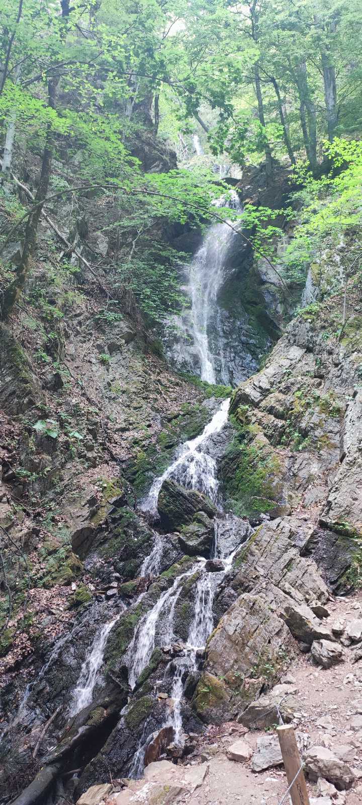
Jelovarnik is a waterfall on the Zaplaninska river, in the south-eastern part of Kopaonik National Park, formed in three cascades in the middle of dense beech forest. According to various sources the total height of the cascades is estimated at between 71 and 82 metres (sources differ, probably in part because the waterfall behaves differently in a dry spell and after heavy rain), and it is most often described as one of the highest waterfalls in Serbia. It was brought to wider public attention in 1998, when a team of geologists recorded it — until then it was known mainly to people from the surrounding villages.
The waterfall is protected today as a natural monument, and the area around it is marked by century-old spruces, firs, beeches and oaks.
Where is it?
Jelovarnik lies at about 1,116 m above sea level, in an area that carries the same name, roughly 2.5 km east of Pančićev vrh and about 25 km west of Brus. It is in the south-eastern part of the National Park, in a deep canyon that the Zaplaninska river carves as it cuts through the forest.
Because of its position in the canyon, largely hidden by dense forest, the waterfall cannot be seen from the surrounding roads or from any viewpoint — you have to physically get to it, either by car to somewhere close by or on foot. That is also why it remained known almost exclusively to people from the surrounding villages for so long, before a team of geologists recorded it in the late 1990s. Its status as a protected natural asset means it is best to stay on the marked path and not disturb the surrounding vegetation, especially when the ground is wet.
How to get there from the centre of Kopaonik
The most practical way is to drive via Brzeće. From Brzeće you turn off at Mramorski prolaz (by the monument) onto a local gravel road, which continues through the village of Čelići — the only village inside the boundaries of the National Park — to a parking area and trailhead near the waterfall. According to available sources, that stretch of gravel road is roughly 4.5 to 6 km long (estimates differ), and from the signpost reading "Jelovarnik" a maintained path about 150 metres long leads to the waterfall itself, which is only a few minutes on foot.
The road is gravel but passable for an ordinary passenger car in dry weather — after heavy rain be more careful, as the state of the surface changes. Part of the route runs through the territory of Kopaonik National Park, where an electronic entry fee applies to passenger vehicles (currently around 300 dinars for a day ticket). If you already hold a valid ticket from arriving on Kopaonik, it should as a rule cover this trip too, but check the current conditions at naplatanpk.rs or at the info centre before setting off, as rules and prices can change.
An alternative for hikers: the waterfall can also be reached on foot, as part of a longer hiking tour that starts with the cable car to Pančićev vrh, passes through Nebeske stolice and then descends to Jelovarnik. This option is considerably more demanding — around 15 km in total and 5–6 hours of walking over moderately difficult to difficult terrain — and is intended for experienced hikers rather than an average family outing.
What is the walk like?
If you drive to the parking area and trailhead near the waterfall, the walk is short — about 150 metres along a maintained forest path, roughly 5 minutes. The path leads through a deep canyon and ends at a point from which the waterfall is visible. The ground is neither paved nor suitable for a pushchair, but for an adult and for children who already walk confidently it is entirely manageable.
If you choose the longer hiking option via Pančićev vrh and Nebeske stolice, that is a proper mountain tour over natural, in places steep terrain, requiring suitable footwear and fitness.
How much time to allow
For a trip by car from the centre of Kopaonik — the drive to Brzeće and on along the gravel road, the short walk to the waterfall, time spent there and the return — it is realistic to allow between 2 and 4 hours, depending on how long you linger and exactly where you start from. For the walking option via Pančićev vrh, plan a full day, given that the tour itself takes 5–6 hours.
Is Jelovarnik suitable for children?
For the shorter option (driving close to the waterfall, then a short walk of about 150 m) — yes, with the usual supervision you would apply on any forest path beside water. The path is not dangerous, but it is natural terrain, uneven in places, so it is not suitable for a pushchair or for children who are only just learning to walk. We would not recommend the longer hiking option via Pančićev vrh and Nebeske stolice with younger children — that is a multi-hour tour at a demanding pace.
Safety on the trail
There is nothing unusually risky about visiting Jelovarnik if you follow the basic rules for behaving near water and in canyon terrain: stay on the maintained path rather than cutting across the surrounding rocks, avoid going near the edge and the wet rock surfaces right by the waterfall (they are slippery even in dry weather), and do not enter the water below the cascades — the bottom is uneven and the water stays cold even in summer. If you have children with you, keep an eye on them along the whole stretch near the water, not only at the viewing point itself.
What to bring
- Comfortable footwear with good grip (the ground near the water can be damp and slippery)
- Water, especially if you continue onto the longer tour
- Clothing suited to changeable mountain weather, even in summer
- Insect repellent — part of the route runs through dense forest
- A camera or phone — this is one of the more photogenic spots on Kopaonik
When is the best time to visit?
The summer months are the most practical time to visit — the gravel road is generally in better condition then, and the days are long enough to plan the trip calmly. The waterfall is at its most impressive immediately after rain, or in a period when the flow of the Zaplaninska river is higher; in longer dry spells the volume of water can be noticeably lower. If you plan the trip after heavy rainfall, also allow for the possibility of the gravel road being in poorer condition.
What else to see nearby
A trip to Jelovarnik combines well with a look around Brzeće, where the access road starts — a tourist settlement with its own accommodation and restaurants, where you can stop for coffee or lunch before or after the waterfall. The village of Čelići, which the access road passes through, is the only settlement inside the boundaries of the National Park and is worth a brief stop if you are curious about life in the heart of the park. If you want to make the most of the day, you can head up to Pančićev vrh by cable car in the morning and only call in at Jelovarnik on the way back in the afternoon — though doing both in one day means allowing for a longer, more active schedule.
For a broader overview of what to do on the mountain in summer, see our What to do on Kopaonik in summer — 16 best activities, and if you are planning a whole weekend, Jelovarnik fits naturally into day two of the plan described in A summer weekend on Kopaonik.
Jelovarnik at a glance
- Type of trip
- Drive plus a short walk (or a longer hike via Pančićev vrh)
- Difficulty
- Easy for the short option; moderate to difficult for the longer hike
- Duration
- 2–4 hours (by car); 5–6 hours (hike via Pančićev vrh)
- Car
- Recommended — part of the road is gravel, passable in dry weather
- Children
- Yes for the short option with supervision; the longer hike is not for young children
- Equipment
- Comfortable footwear, water, clothing for changeable weather
- Best time
- Summer, ideally after rain for a higher flow of water
Frequently asked questions
How high is the Jelovarnik waterfall?
Sources differ — the height most often quoted is between 71 and 82 metres in three cascades, depending on whether it is measured in a dry period or after rain. Either way, it is one of the highest waterfalls in Serbia.
Do I need an off-road vehicle to get there?
As a rule, no — the road from Mramorski prolaz is gravel but passable for an ordinary passenger car in dry weather. After heavy rain or in poor conditions, caution is warranted.
Is there an entrance fee for the waterfall?
Access to the waterfall itself has no separate ticket, but part of the route passes through Kopaonik National Park, where an electronic entry fee applies to passenger vehicles. Check the current conditions before setting off.
How much time should I allow for the whole trip?
For a trip by car from the centre of Kopaonik, including the drive, the short walk and time at the waterfall, it is realistic to allow 2 to 4 hours. The walking option via Pančićev vrh requires a full day.
Can Jelovarnik be reached on foot from the centre of Kopaonik?
Yes, there is a longer hiking tour that starts with the cable car to Pančićev vrh, passes through Nebeske stolice and descends to the waterfall — around 15 km in total and 5–6 hours of walking, intended for more experienced hikers.
Is Jelovarnik suitable for families with children?
The shorter option (driving close to the waterfall, then a short walk) is manageable with children who walk independently and confidently, with the usual parental supervision. The longer hike is not suited to young children.
When is the waterfall best for photography?
Immediately after rain, when the flow of water is higher; morning hours, when light filters through the canopy of the canyon, also give good conditions for photographs.
Back to the centre of Kopaonik
After a trip to Jelovarnik, the drive back to the centre of Kopaonik takes roughly as long as the way out. If you are looking for a comfortable base near the centre from which to organise trips like this, Konaci 119 is a renovated 22 m² apartment in the Sunčani vrhovi complex, with a kitchen, Wi-Fi, a Smart TV and self check-in — practical for up to three guests who want a quiet base for exploring the surroundings.
More information on the Konaci 119 home page.